

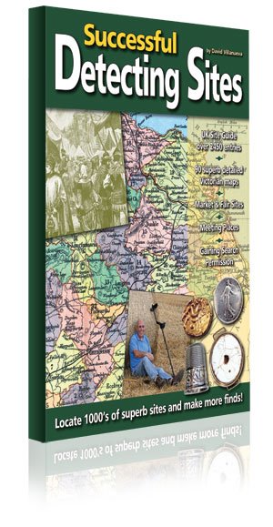
Successful Detecting Sites, English Book
Tax included.
Device not in stock
Ihre gesetzlichen Gewährleistungsrechte


Description
Successful sites, according to most metal detectorists, are those with the potential to produce large quantities of quality coins and artefacts from all periods, from the Bronze Age to the modern day.
Using rare 18th- and 19th-century sources, David Villanueva has drawn on more than 30 years of experience in metal detecting and historical research to compile this exciting guide to thousands of potentially successful detecting sites throughout the United Kingdom, with histories stretching back hundreds or even thousands of years.
This is the only site guide you will ever need. The author of Site Research clearly explains how to identify a host of successful detecting sites from every place in the guide, helping to keep your finds bag overflowing for years to come.
To lead you to these sites, the book includes a wealth of valuable information, together with superb facsimiles of 90 highly detailed Victorian maps covering every UK county, giving you a complete antique county atlas as well.
The maps for England and Wales come from Thomas Dugdale’s Curiosities of Great Britain (1846) and were drawn by the renowned mapmaker Joshua Archer. They contain an abundance of information for detectorists, detailing the hundreds, market towns, manors, polling places, roads, rivers, canals, mail coach routes and the few railways that existed at the time. Also included are many castles, abbeys, priories, Roman sites and even some coin hoards.
The maps for Scotland and Northern Ireland come from two Philip’s atlases published in 1882 and 1883 and were drawn by another famous mapmaker, John Bartholomew.
They outline every parish in Scotland and every barony in Northern Ireland.
The maps of the Channel Islands and the Isle of Man come from the National Gazetteer, published in 1868.
CONTENTS
History of Markets and Fairs in Britain
The Siting of Markets and Fairs
Finds from Market and Fair Sites
Finds from the Routes
Open-Air Political Meetings
The Siting of Meeting Places
Finds from a Hundred Court Site
Practical Map Reading
Finding the Sites
County Atlas and Site Guide for England and Wales
County Atlas and Site Guide for Scotland
County Atlas and Site Guide for Northern Ireland & Offshore Islands
Gaining Search Permission – The Project Approach
Bibliography and Sources
Code of Practice
250mm x 190mm, over 232 pages
Specifications
Scope of delivery
Manufacturer
Documents
Successful sites, according to most metal detectorists, are those with the potential to produce large quantities of quality coins and artefacts from all periods, from the Bronze Age to the modern day.
Using rare 18th- and 19th-century sources, David Villanueva has drawn on more than 30 years of experience in metal detecting and historical research to compile this exciting guide to thousands of potentially successful detecting sites throughout the United Kingdom, with histories stretching back hundreds or even thousands of years.
This is the only site guide you will ever need. The author of Site Research clearly explains how to identify a host of successful detecting sites from every place in the guide, helping to keep your finds bag overflowing for years to come.
To lead you to these sites, the book includes a wealth of valuable information, together with superb facsimiles of 90 highly detailed Victorian maps covering every UK county, giving you a complete antique county atlas as well.
The maps for England and Wales come from Thomas Dugdale’s Curiosities of Great Britain (1846) and were drawn by the renowned mapmaker Joshua Archer. They contain an abundance of information for detectorists, detailing the hundreds, market towns, manors, polling places, roads, rivers, canals, mail coach routes and the few railways that existed at the time. Also included are many castles, abbeys, priories, Roman sites and even some coin hoards.
The maps for Scotland and Northern Ireland come from two Philip’s atlases published in 1882 and 1883 and were drawn by another famous mapmaker, John Bartholomew.
They outline every parish in Scotland and every barony in Northern Ireland.
The maps of the Channel Islands and the Isle of Man come from the National Gazetteer, published in 1868.
CONTENTS
History of Markets and Fairs in Britain
The Siting of Markets and Fairs
Finds from Market and Fair Sites
Finds from the Routes
Open-Air Political Meetings
The Siting of Meeting Places
Finds from a Hundred Court Site
Practical Map Reading
Finding the Sites
County Atlas and Site Guide for England and Wales
County Atlas and Site Guide for Scotland
County Atlas and Site Guide for Northern Ireland & Offshore Islands
Gaining Search Permission – The Project Approach
Bibliography and Sources
Code of Practice
250mm x 190mm, over 232 pages
Customer Reviews